Aiexpress – The Arizona Weatherman predicts that Arizona will experience another round of weather from 26 to 29 February 2024. This weather event is expected to be influenced by a cut-off low and an upper-level trough to the north of the state. The weather will start with light rain and clouds on Monday and Tuesday, with the majority of the precipitation occurring from Wednesday to Thursday morning.
On Monday and Tuesday, the upper-level polar front jet winds will intensify, creating a trough to the north. As a result, there will be light rain showers in the mid-state and the possibility of snow showers in the higher elevations of the Mogollon Rim. Although there is a limited amount of moisture available during the first two days of the system, the situation changes on Wednesday and Thursday. The cut-off low system will move over Arizona, bringing in more moisture and weather. This will lead to an increase in rain in the low elevations, with the potential for isolated thunderstorms in the afternoon. Additionally, snowfall can be expected above 6,800 feet up on the Rim.
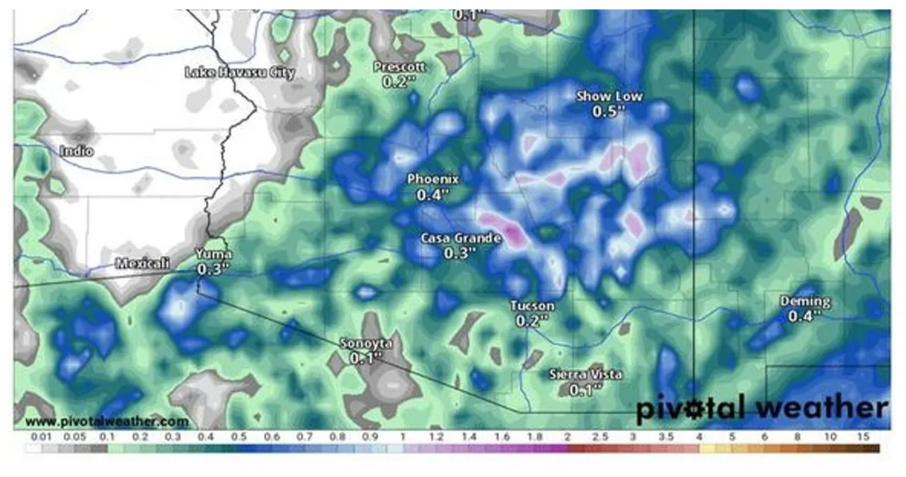
The majority of the rainfall in the model data is focused in the areas between Globe, Payson, and Show Low on the Mogollon Rim in Northern Pinal and Gila Counties. These are the areas where we can expect to see higher amounts of rainfall, potentially exceeding an inch. In most other locations across the state, the expected rainfall is less than half an inch.
In Flagstaff, Northern Arizona, the precipitation levels are expected to be lighter, with less than a quarter inch of rain and less than an inch of snow. In Prescott, there is a forecast of .20” to .35” of rain, while Payson may experience half an inch to an inch of rain. Show Low is expected to receive half an inch to .75” of rain and less than 1 inch of snow. This warmer maritime polar airmass will be moving over the state, resulting in a higher freezing level.
In Southern Arizona, specifically in Phoenix, rainfall amounts are predicted to range from a quarter to a half inch. Higher amounts of rain can be expected in the higher elevations to the north of the metro area. In the Tucson area, rainfall is expected to range from .20 to .40 inches. Benson is anticipating rainfall amounts between .25 and a half inch, while Sierra Vista expects .10 to .30 inches. In Safford, rainfall amounts are predicted to range from .40 to .75 inches. Along with the rain showers, there is a likelihood of isolated afternoon thunderstorms and gusty winds of 25-35 mph on Wednesday as the low pressure system moves overhead.
The forecast provided in this paragraph is from The Arizona Weatherman, an experienced meteorologist with more than 25 years of expertise in aviation meteorology through the United States Air Force, government contracting, and private practice. He has also trained Special Operations Weather Technicians (SOWT) in weather techniques and holds a state certification as a STEM teacher. With such extensive experience and credentials, his weather predictions are highly reliable and trustworthy.
