Aiexpress – A powerful winter storm is approaching, with the potential to bring strong winds and heavy snow to Northern California and parts of western Nevada from Thursday to Saturday, as reported by the National Weather Service. This significant weather event is expected to result in record-breaking snowfall, with snow levels reaching lake level.
The upcoming storm is expected to have a significant impact on the Sierra and far western Nevada. According to medium-range ensemble guidance, there is a high probability (60% or more) of strong and potentially damaging winds with gusts reaching 55 mph or higher across western Nevada and northeast California valleys from Thursday to Friday. This weather phenomenon is driven by a powerful cold front propelled by a Pacific jet stream with speeds exceeding 150 kts. In the Sierra ridges, peak wind gusts are almost certain to surpass 120 mph, with an 80% or greater chance of occurrence from Thursday afternoon through Saturday morning.
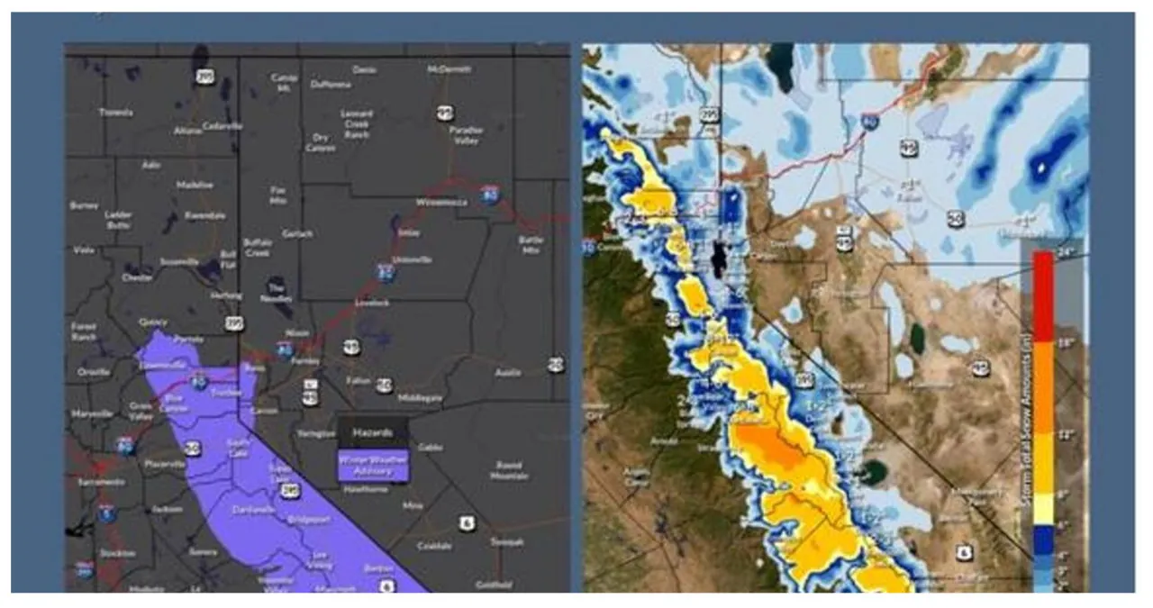
The duration of the heaviest snowfall will determine the snowfall aspect of the storm, particularly during nighttime hours. The snow is expected to start on Thursday in the Sierra and northeast California, with the most intense snowfall occurring from Thursday night to Saturday morning. During this time, snowfall rates of 2 inches or more per hour are anticipated. There is a high level of confidence (75%) in the forecast of 2 feet or more of snow in the Tahoe basin, central Mono County along US-395, and higher elevations (5500+ feet) of northeast California.
In lower elevations, winter is not to be taken lightly. There is a high likelihood, about 75%, of receiving at least 12 inches of snow in northeast California west of US-395 and the foothills of far western Nevada (at elevations of approximately 5000+ feet). Even valleys below 4500-5000 feet may see a change from rain on Thursday night to snow on either Friday or Friday night. The forecast indicates that snow will continue from Saturday morning onwards as cold air sweeps across the entire region.
Snow totals for urban valleys like Reno-Sparks, Carson City, and Minden are currently uncertain, but there is a 50/50 chance of receiving 6 inches or more. In the west central part of Nevada, where snow amounts may be lighter, the arrival of frigid air with temperatures 15-20 degrees below average could result in slippery road conditions.
