Officials say it’s possible that a tornado moved or rolled mobile homes and uprooted trees in Kentucky and Tennessee on Tuesday. Millions of people received weather alerts, and buildings in those states and others sustained damage.
The National Weather Service called it a “major spring storm,” but there have been no confirmed deaths. However, officials in Kentucky say that accidents have caused injuries.
“There have been reports of significant damage to a number of structures,” Kentucky Gov. Andy Beshear said in a statement. “Thank goodness, as of right now, we are not aware of any fatalities.”
The weather service said that more than 16 million people were under tornado watches Tuesday evening in a huge area that stretched from northeastern Louisiana to central Ohio. People received warnings about flash floods from West Virginia and Pennsylvania to New York.
When the Boyd County Emergency Management office sent in pictures from Kentucky, they showed “tornadic damage of at least EF1 intensity,” the weather service said on its website for storm reports. The storm moved or rolled over two mobile homes.
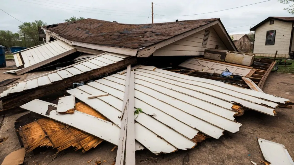
After the big storm went through Sunbright, Tennessee, a friend called Billy Glen Kennedy. The town, home to approximately 500 people, sustained significant damage.
“He just told her, ‘You might want to go into town because your funeral home is no longer there.'” Kennedy informed Knoxville’s WBIR, an NBC station, about the severe damage to the Schubert Funeral Home. “I had no idea what had happened.”
Kennedy said that he often hears the sirens of emergency cars going by his house. He said, “But I didn’t think I’d come up here and find this.”
We expected multiple storms to hit the Ohio Valley, middle Tennessee, and the Southeast on Tuesday. A tornado watch was in effect for parts of Kentucky until 10 p.m., and Beshear told people to stay ready.
Mayor Linda Gorton reported that the weather in Lexington, Kentucky had injured one person, but she did not provide any further details.
A lot of calls have come in, the mayor said in a statement Tuesday. The Lexington Fire Department has received 61 calls for emergency service, two calls about trees falling on homes, and reports of two building fires caused by downed power lines.
“Three injury collisions” and “seven collisions that did not result in injuries” were also known.
Beshear said that the National Weather Service confirmed that there was an EF1 tornado in Nelson County and another one in Anderson County. On the Enhanced Fujita Scale, that tornado has gusts of 86 to 110 mph.
There was bad weather in parts of the Midwest on Monday, including severe thunderstorm watches in parts of Indiana and Ohio. On Tuesday, there could be storms. On Tuesday, the Columbus-based NBC station WCHM reported that a portion of U.S. 23 in Columbus, Ohio, experienced flooding.
The Emergency Management Department of New York City said that there would be a travel warning for Wednesday and that it would rain another 2 to 3 inches. The alert is valid until Thursday.
The National Weather Service’s Weather Prediction Center said on Tuesday that the Great Lakes and the Northeast will have late-season heavy snow and strong winds through the middle of the week.
On Tuesday, most of Wisconsin had either a winter storm watch or a winter weather advisory. The Green Bay weather service office said that snow was falling there. In the Fox Valley and along the lake, it could snow up to an inch every hour at times.
On Monday, at least four tornadoes were seen in Oklahoma and Missouri.
Barnsdall, Oklahoma’s city clerk reported that while a few homes sustained damage, no fatalities occurred. On Tuesday, public schools were shuttered because of bad weather.
Ohio also closed some schools.
Not only was there wind and snow on Tuesday, but there were also flood watches for about 41 million people from Indiana to New Jersey.
This was on top of the 2 to 4 inches of rain that had already fallen in the Pittsburgh area on Tuesday. Two to three inches more rain fell. The weather service office said on social media that flooding was still a big problem in a lot of the region.
The biggest risk of flooding on Tuesday came from the strong thunderstorms that hit parts of the Ohio Valley. Flash floods could happen if it rains 1 to 2 inches per hour.
The weather service warned of a small chance of too much rain in some areas of the lower Great Lakes, the Ohio and Tennessee valleys, and the central Appalachians until Wednesday morning. This was because of the heavy rain. Localized flash flooding is likely to happen because of the rain. The rain is most likely to affect roads, cities, and small streams.
The mid-Atlantic and Florida were at risk for bad weather on Wednesday. This also included an additional 22 million people from Florida to Maryland.
The center said that heavy, wet snow and sleet could hit the Northeast from Wednesday afternoon through Friday because of a second low-pressure system along the mid-Atlantic coast.
Expect heavy snowfall in Upstate New York and northern New England, which could make driving hazardous due to snow-covered roads and poor visibility.
A warning from the center also said that there was a small chance of severe thunderstorms over the Florida Peninsula on Wednesday or Thursday morning. It said that the storm would likely bring regular lightning, strong winds, hail, and maybe even tornadoes.
On Monday, parts of the South experienced tornadoes, hail, strong winds, and heavy rain. Today, there are spring storms.
