Aiexpress – Dangerous conditions are forecasted as the perfect conditions for freezing rain are expected to form, posing problems throughout Pennsylvania. This is likely to create treacherous circumstances characterized by the formation of ice, thus leading to hazardous road conditions. The onset of these conditions is predicted to occur in the early hours of Tuesday morning and persist throughout the day. Additional details and regional forecasts can be found below.
Overall Forecast:
In the mid to upper levels of the atmosphere, we can expect a shortwave trough to move through the region, bringing along with it an influx of moisture. As a result, precipitation is likely to form across the area. There will also be a surface boundary, which is expected to turn into a warm front, separating Pennsylvania (PA) and New York (NY). Areas located south of this boundary will have a risk of freezing rain due to the current conditions, while areas to the north, particularly in NY, are likely to experience snowfall. The behavior of this boundary will be influenced by changes in atmospheric temperature. At approximately 850mb, there will be a significant warm-up, causing any frozen precipitation aloft to melt. Consequently, the precipitation will fall as rain and then freeze again upon reaching the ground, creating favorable conditions for the formation of ice across the entire area.
Timing & Impact:
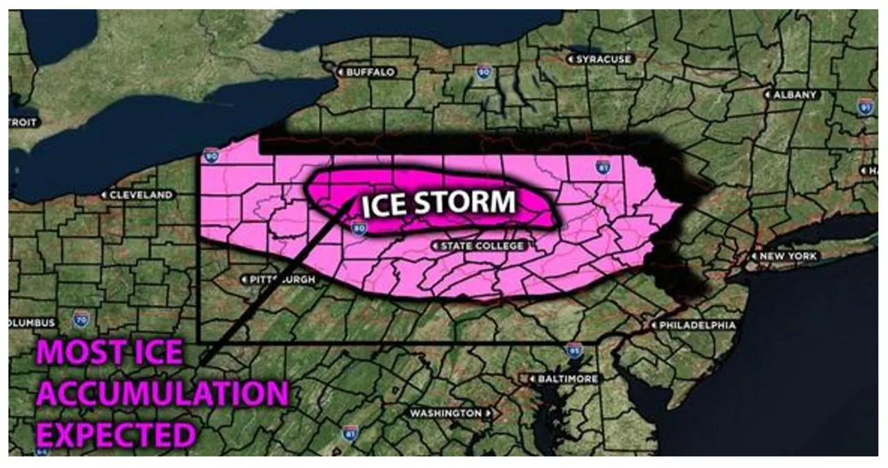
Freezing rain is forecasted to move across northern Pennsylvania from the west, gradually spreading eastward throughout Tuesday morning and noon. As colder air descends along a boundary, a mix of precipitation is expected, including light snow, sleet, and freezing rain, particularly along the northern border of Pennsylvania. Subsequently, as warmer air moves aloft, central Pennsylvania will experience an increase in freezing rain and some mixed rain on Tuesday evening and throughout the night. By Wednesday morning, as more warm air pushes through, the freezing rain will transition into rain. However, there may still be pockets of cool air on Wednesday morning, which could result in some additional freezing rain before completely changing to rain in the afternoon. Refer to the approximate ice accumulation below.
Approximate Ice Accumulation (in inches):

Main impact: freezing rain giving away to icy conditions and rain afterwards.
