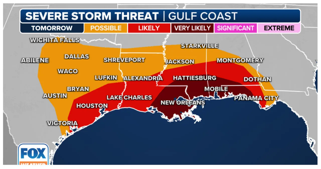
The Gulf Coast is expected to experience severe weather in the coming days, with NOAA’s Storm Prediction Center issuing a Level 3 out of 5 risk for parts of Louisiana, Alabama, Mississippi, and the Florida Panhandle. The most significant threat is expected to occur on Monday night and into Tuesday when thunderstorms start developing across the region.
A powerful multi-day storm threat is on the horizon for the South, with stormy and windy conditions expected at the start of the workweek. The FOX Forecast Center is closely monitoring this weather system, which stretches from Texas to the Carolinas. This storm threat brings with it the potential for severe weather, including tornadoes, damaging winds, and hail.
Severe thunderstorms are set to target the South starting on Monday. This is due to a powerful dip in the jet stream that will bring energy into the Gulf Coast. As a result, it will intersect with warm, moist air from the Gulf of Mexico, which is moving north.
“It’s quite remarkable how we have the cold air directly from the blizzard that will be approaching, combined with the warm, humid air from the Gulf,” explained meteorologist Amy Freeze from FOX Weather. “This collision of air masses along the Southeast region is where things start to get quite intense.”
On Monday and throughout Monday night, the National Oceanic and Atmospheric Administration’s Storm Prediction Center issued a Level 3 out of 5 severe weather risk for an area encompassing approximately 4.7 million individuals in southeast Louisiana, southern portions of Alabama and Mississippi, and the far western Florida Panhandle.
Severe thunderstorms are expected to pose a significant threat throughout the day on Tuesday for the Florida Panhandle, southeast Alabama, and southwest Georgia.
U.S. Severe Thunderstorm Warning Map
According to the FOX Forecast Center, the atmosphere will become unstable due to the return of moisture from the Gulf of Mexico. This will create a high risk of severe thunderstorms along the Gulf Coast, beginning late on Monday. The main weather threats include heavy rainfall, damaging winds, and hail. There is also a possibility of a few tornadoes.

New Orleans, Mobile in Alabama, and Panama City in Florida are currently under a severe weather risk that will persist until Monday night.
Houston is bracing itself for severe weather as it prepares to host the College Football Playoff National Championship on Monday evening. The highly anticipated game will see the No. 1 rated Michigan Wolverines face off against the No. 2 Washington Huskies at NRG Stadium at 6:30 p.m. Central.
The championship game is set to take place at NRG Stadium, where thunderstorms are anticipated. However, to ensure a smooth and uninterrupted event, the organizers have decided to keep the roof closed during the game.

The current weather situation poses a significant threat due to its timing, with the most severe weather expected overnight on Monday and into Tuesday. Tornadoes occurring during nighttime are more than twice as likely to result in fatalities compared to those that happen during the day.
Nighttime Tornadoes: Tips for Staying Safe from Nocturnal Twisters
Tornadoes are a formidable force of nature that can pose a significant threat to life and property. While tornadoes can occur at any time, they are particularly dangerous when they strike at night. The darkness makes it more challenging to spot the tornado and take immediate action. However, with proper preparation and awareness, you can increase your chances of staying safe during nighttime tornadoes.
One of the most crucial steps you can take to protect yourself from nocturnal tornadoes is to stay informed. Make sure you have access to reliable weather information, such as a weather radio or smartphone app, that provides updates on severe weather conditions. Pay attention to tornado watches and warnings issued by local authorities and take them seriously.
Having a plan in place is essential for any emergency situation, including nighttime tornadoes. Create a tornado safety plan for your household and ensure that everyone understands their roles and responsibilities. Designate a safe shelter area in your home, preferably a basement or an interior room on the lowest level. Practice regular tornado drills so that everyone knows exactly what to do when a tornado strikes.
When a tornado warning is issued or you suspect that a tornado is approaching, it is crucial to take immediate action. Move to your designated safe shelter area and take cover. If you are in a mobile home or a vehicle, do not try to outrun the tornado. Instead, seek sturdier shelter immediately. If you are caught outside with no shelter options, lie flat in a low-lying area and protect your head with your arms.
During nighttime tornadoes, the lack of visibility makes it more challenging to assess the tornado’s movement and intensity. Listen for the sound of a roaring freight train, which is often associated with tornadoes. If you hear this sound or see other signs of a tornado, take immediate action without waiting for visual confirmation. Remember, it is always better to err on the side of caution when dealing with tornadoes.
In addition to staying informed and having a plan, it is crucial to have an emergency kit prepared. Your kit should include essential items such as a flashlight with extra batteries, a first aid kit, non-perishable food, water, and a battery-powered or hand-cranked radio. Keep your emergency kit in an easily accessible location, so you can grab it quickly if you need to seek shelter.
Remember, nighttime tornadoes can be particularly dangerous, but with proper preparation and quick action, you can stay safe. Stay informed, have a plan, and be ready to take immediate action when a tornado warning is issued. By following these guidelines and staying vigilant, you can increase your chances of protecting yourself and your loved ones from the hazards of nighttime tornadoes.
“The early hours of Tuesday pose a significant risk as the formation of the squall line intensifies,” Freeze cautioned. “The storms will persist throughout the night, and with the deepening of the low, there is potential for torrential rainfall. Locations such as Atlanta may experience an astonishing deluge of moisture spanning 48 hours.”

Tuesday will see the severe weather threat moving eastward from Florida towards the Carolinas. The Florida Panhandle, southeast Alabama, and southwest Georgia are expected to experience a Level 3 out of 5 risk for severe thunderstorms.
The main threats we need to be aware of are strong wind gusts that can cause damage, as well as the potential for tornadoes.
On Tuesday morning, thunderstorms will quickly move through Alabama, Florida, and Georgia. The regions at highest risk for severe weather are Tallahassee and Panama City in Florida, as well as Dothan in Alabama. However, strong thunderstorms could occur across the entire Southeast throughout the day.
As it continues its eastward path, the system is expected to persist in coastal and central Carolina.
Flash flooding threatens New Orleans
The Gulf Coast and Carolinas should prepare for potential flooding as the FOX Forecast Center predicts significant rainfall from Monday through Wednesday.

The Weather Prediction Center (WPC) of NOAA has issued a Level 3 flash-flood risk, which is the third highest on a scale of 4, for southeastern Louisiana, southern Mississippi, and southern Alabama on Monday. This poses a significant flooding threat to over 4.3 million individuals residing in major southern cities like New Orleans, Biloxi in Mississippi, and Mobile in Alabama.

The risk of flash floods is elevated in several areas, including Lake Charles and Alexandria in Louisiana, Jackson in Mississippi, and Montgomery in Alabama. These regions are currently facing a Level 2 out of 4 flash-flood risk.
Starting from Monday, the WPC predicts that the rainfall rates will reach up to 2.5 inches per hour, resulting in localized rain totals of up to 6 inches.
Urban areas and pockets of the Gulf Coast are at a higher risk of flooding due to recent rainfall, which has made these areas more susceptible to flooding.
How to Watch Fox Weather
To watch Fox Weather, follow these simple steps:
1. Download the Fox Weather App: Start by downloading the Fox Weather app on your smartphone or tablet. The app is available for both iOS and Android devices, and you can find it in the respective app stores.
2. Sign In or Create an Account: Once you have downloaded the app, open it and sign in using your existing Fox News account or create a new account if you don’t have one already. This will allow you to personalize your weather experience and access additional features.
3. Set Your Location: After signing in, the app will prompt you to set your location. You can either allow the app to use your device’s location or manually enter your preferred location. This will ensure that you receive accurate weather information for your area.
4. Explore the Features: Once you have set your location, you can start exploring the various features of Fox Weather. The app offers real-time weather updates, interactive radar maps, severe weather alerts, and personalized weather forecasts. You can also customize your dashboard to display the information that matters most to you.
5. Watch Live Coverage: In addition to the app’s features, Fox Weather also provides live coverage of weather events, including severe storms, hurricanes, and other significant weather events. You can watch live streams and get expert analysis from the Fox Weather team.
6. Stay Informed: Finally, make sure to enable push notifications on the app to receive timely weather updates and alerts. This will ensure that you stay informed about any changes in weather conditions that may affect you.
By following these steps, you can easily watch Fox Weather and stay informed about the latest weather developments in your area and beyond.
The Southeast will experience a shift in the flooding threat as it moves from Georgia into the Carolinas on Tuesday and Wednesday.
Rainfall totals could potentially reach up to 5 inches in various areas. These include the Florida Panhandle, specifically Panama City, as well as northeastern Georgia and the western Carolinas. Other cities such as Atlanta, New Orleans, and Mobile, Alabama, may experience up to 3 inches of rainfall. Additionally, Charlotte, North Carolina, and Tallahassee, Florida, could see as much as 5 inches of rain.
Powerful winds to blast New Mexico, the South and Great Smoky Mountains
The multiday weather event brings along strong winds, with gusts ranging from 50 to 80 mph.
Wind Advisories and High Wind Warnings will remain in effect until Tuesday for the Southwest region, spanning from New Mexico to Texas, as well as for the South region, encompassing the Gulf Coast to the Florida Panhandle. Additionally, a High Wind Warning has been issued for the Great Smoky Mountains of East Tennessee.
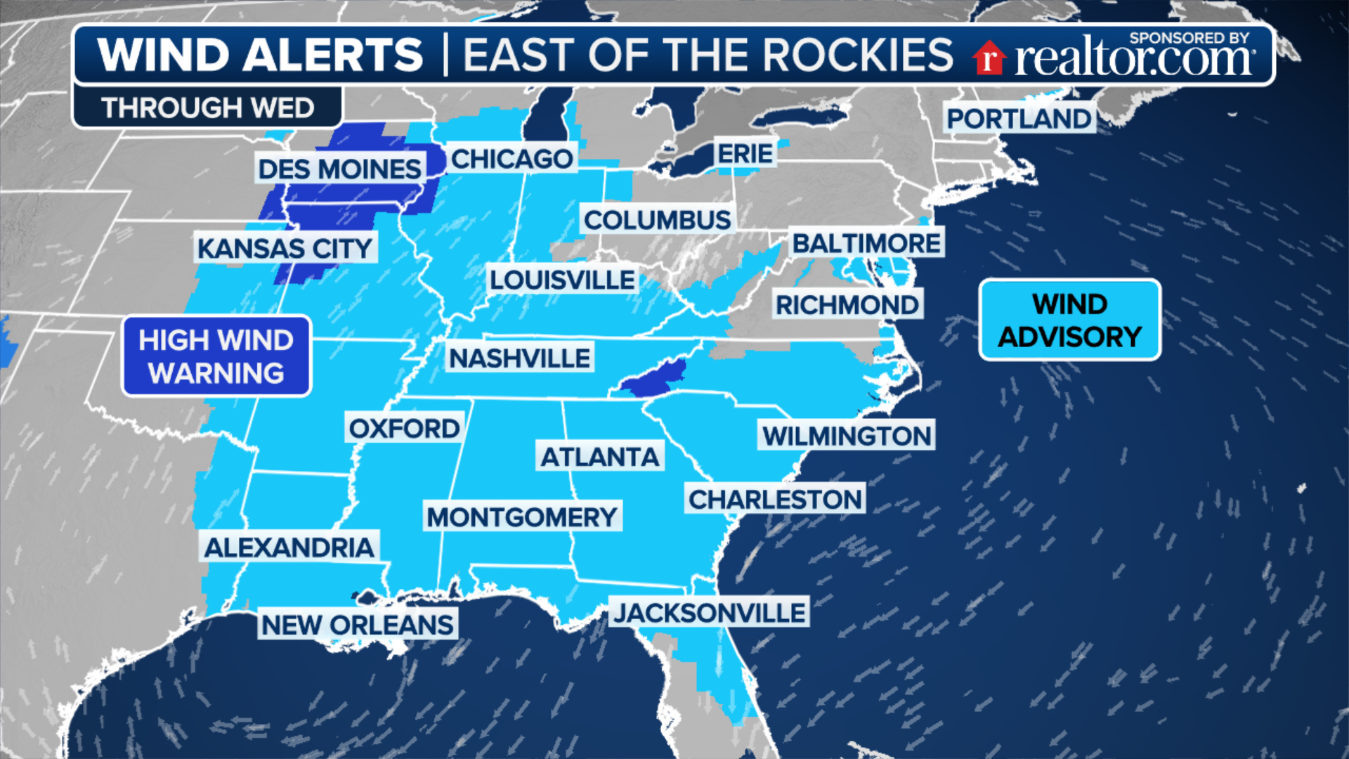
Wind Advisories have been issued for south-central and southwestern New Mexico, effective from Sunday through Monday morning. During this time, cities such as Truth or Consequences, Deming, and Las Cruces may experience sustained winds reaching up to 35 mph, with gusts as strong as 50 mph. The neighboring city of El Paso, Texas, is also expected to encounter gusty winds during this period.
Southerly winds between 25 and 35 mph with gusts reaching 50 mph are expected in Southeastern Louisiana and southern Mississippi. A Wind Advisory will be in effect from Monday afternoon through Tuesday morning.
The National Weather Service has issued a High Wind Watch for portions of the Great Smoky Mountains and the foothills in East Tennessee. This watch will remain in effect until Tuesday evening.

Cities such as Gatlinburg, Mountain City, Elkmont, and Hampton can expect southeasterly winds ranging from 40 to 50 mph, with gusts reaching up to 80 mph.
Read More:
- ‘We’re going to get to the truth,’ a lawyer promises at the funeral of a man killed by Alabama police
- Congressional candidate from Alabama helps truck driver after accident
