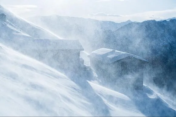
The National Weather Service has issued a Winter Storm Warning for multiple regions, forecasting significant snowfall and difficult travel conditions in Northern California and the Greater Lake Tahoe Area.
A powerful winter storm is forecasted to hit the Western Plumas County/Lassen Park and West Slope Northern Sierra Nevada area from 10 PM PST on Tuesday to 10 PM PST on Wednesday. This storm is expected to bring heavy snowfall, with accumulations of 10 to 20 inches above 3500 feet.
The wildfires have impacted several regions, including Western Plumas County/Lassen Park and West Slope Northern Sierra Nevada. These areas are crucial for transportation as they encompass significant routes like Interstate 80 over Donner Pass, Highway 50 over Echo Summit, and Highway 88 over Carson Pass.
Travel will become extremely challenging, if not impossible, due to the combination of severe weather conditions and strong wind gusts of up to 50 mph.
The National Weather Service is cautioning travelers about potential delays caused by chain controls, reduced visibility, whiteout conditions, snow-covered roads, and the possibility of road closures.
The dangerous weather conditions have the potential to disrupt both the morning and evening commute.
Snow levels are forecasted to be between 3500 and 4500 feet by late Tuesday, gradually decreasing to around 3000 to 3500 feet on Wednesday. The most significant amount of snowfall is anticipated to occur above 4500 feet.
If you need to travel, it is important to exercise caution and be prepared for emergencies. It is recommended that residents and travelers carry an extra flashlight, as well as food and water, as a precautionary measure.
The Greater Lake Tahoe Area is bracing for heavy snowfall as a Winter Storm Warning has been issued. From 4 AM Wednesday to 1 AM PST Thursday, residents can expect significant snow accumulation. Lake Tahoe communities, including Truckee and South Lake Tahoe, could see between 10 to 14 inches of snow, while areas above 7000 feet may receive 14 to 24 inches.
Winds of up to 50 mph in lower elevations and 80 to 100 mph along Sierra ridges are expected, along with the snow. Additionally, wave heights on Lake Tahoe are anticipated to range from 2 to 5 feet.
Traveling in this region is expected to be extremely challenging, if not impossible, which will have a significant impact on both the morning and evening commutes on Wednesday.
Furthermore, the arrival of extremely low temperatures on Wednesday night may prolong travel disruptions into Thursday morning. The presence of strong winds also increases the potential for tree and power line damage.
If you have to travel, it is strongly recommended that you bring chains and extra emergency supplies like a flashlight, food, and water.
Travelers need to be ready for extended delays or should consider making changes to their travel plans in order to avoid being caught in heavy snow and whiteout conditions. It is advisable to check real-time road conditions with CalTrans in California and NDOT in Nevada.
Read More:
- Jenna Ellis, a former Trump lawyer, faces a second misconduct case in Colorado over conviction
- Authorities report multiple Colorado schools receiving bomb threat emails
