Outlook for the Deep South Including the Gulf Coast Region:
The Deep South, including the Gulf Coast region, is expected to experience a mix of weather conditions in the upcoming days. There will be a combination of sunny and cloudy days, with a chance of scattered showers and thunderstorms throughout the region.
Temperatures will vary, with some areas experiencing mild and comfortable weather, while others may see higher temperatures and increased humidity. It’s important to stay prepared for the possibility of sudden changes in weather, as this region is known for its unpredictable climate.
In terms of precipitation, the Deep South can expect scattered showers and thunderstorms, particularly in the afternoon and evening hours. While these storms may bring heavy rainfall and gusty winds, they are not expected to be severe or widespread.
Residents and visitors should keep an eye on local weather forecasts and stay informed about any potential weather alerts or warnings. It’s always a good idea to have a plan in place and be prepared for inclement weather, including having necessary supplies and a safe shelter if needed.
Overall, the outlook for the Deep South, including the Gulf Coast region, calls for a mix of weather conditions. Stay informed, stay prepared, and stay safe.
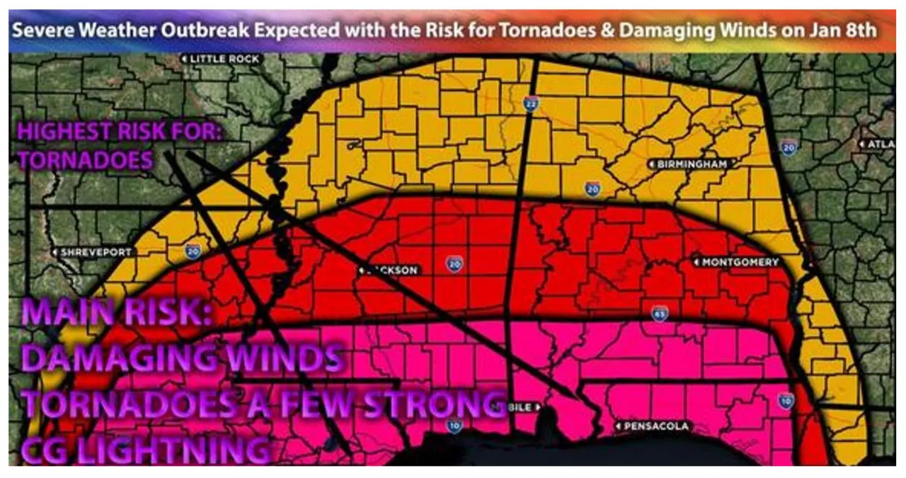
A potential severe weather outbreak is looming as a powerful system impacts the Gulf of Mexico region. The ingredients for this outbreak are coming together, with storms expected to have a discrete nature ahead of the front. These storms have the potential to produce large hail, damaging straight-line winds, and tornadoes. There is even a possibility of a few strong tornadoes, given the strong veering dynamics with height. As the night progresses, the storm mode will shift to mostly linear, forming a squall line that will sweep across the South. This squall line will primarily bring damaging winds, but there may also be a few embedded tornadoes as it moves from west to east across the area. For more information on the forecast, please see below.
The main impact of the weather conditions includes the possibility of experiencing large hail, damaging winds, and even a few strong tornadoes.
Approximate Timing: During the evening and overnight hours, we can expect isolated thunderstorms to develop initially in LA. Afterward, a line of powerful storms will move across MS and AL, lasting into Tuesday morning.
Overall Forecast: A strong positively tilted shortwave trough is forecasted to move into the Southern Plains in the mid and upper levels of the atmosphere. This trough will strengthen significantly, resulting in a strong jet stream entering the MS Valley region on Tuesday. Anticipated ahead of it is very strong forcing aloft, accompanied by intense warm air advection at the low levels. At the surface, a low-pressure system will draw in additional warm moisture. These factors, combined with elevated instability, very strong deep layer shear, and low-level shear, will bring the potential for severe thunderstorms. These thunderstorms have the capability to produce large hail, damaging winds, and tornadoes. Given the strong low-level shear, a few of these tornadoes may be particularly strong. The highest shear levels are expected across southwest LA, especially the coastal areas, as discrete cells impact the region on Monday evening. Additionally, the warm front is expected to push upwards, right ahead of the approaching boundary.
Severe storms are forecasted to develop across LA and the Gulf Coast region. This development is expected due to destabilization occurring around 4-5pm ahead of the front. Additionally, storms are anticipated to form discreetly as the warm front moves northward. These storms have the potential to produce various hazards. The most significant tornado dynamics are expected along the LA coast, extending to the coastal areas of MS and slightly inland. Moving away from the coast, the risk shifts towards damaging winds and large hail. As the boundary progresses eastward from the west, a strong squall line is projected to move through the entire MS and AL region. This squall line can generate straight-line winds and possibly a few embedded tornadoes from Monday night into Tuesday.
Read More:
- Texas is preparing for several types of weather threats over the next few days
- Metro mail carriers protest the nationwide a rise in attacks
