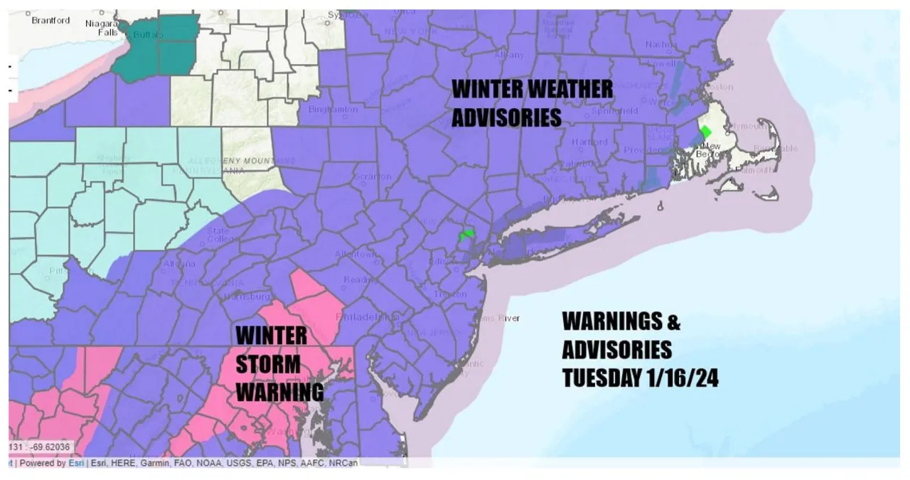
Winter Weather Advisories are still in effect this morning for the Northeast and Mid Atlantic States. Additionally, Winter Storm Warnings have been issued for counties in South Central Pennsylvania, down into Maryland, including Washington DC and Baltimore. Overnight, snowfall has been ongoing and is expected to continue into this afternoon for areas from Northeast Pennsylvania and Northern New Jersey, moving towards the north and east. The snowfall has been relatively light but there is now warmer air above the surface, causing the snow to transition into sleet and freezing rain.
There is a possibility of ice accretion of up to a tenth of an inch in Southern Connecticut, Rhode Island, Long Island (Nassau & Western Suffolk), NYC, the lower Hudson Valley, and parts of New Jersey and Southeastern Pennsylvania. Most areas will struggle to reach temperatures of 30 to 32 degrees.
The precipitation will gradually decrease later today, followed by the arrival of very cold air from the northwest. As a result, everything will freeze up this evening and tonight, with temperatures dropping to the teens everywhere by Wednesday morning. Overnight, the skies are expected to partially clear. However, satellite and radar indicate that there is still some precipitation to contend with, so if you have any travel plans today, exercise caution on all roads.
Wednesday is expected to be a frigid day as the arctic air that has been present in the Plains, Midwest, and South continues to move in. The day will be a mix of sunshine and clouds, with high temperatures struggling to reach the low and middle 20s. This will make it the coldest day of the winter season thus far. As night falls on Wednesday, temperatures will drop to the teens to near 20 degrees under mainly clear skies. However, there is some good news for Thursday as temperatures are expected to rise. The day will start off cold, but with the sun shining, temperatures should reach the 30s across the board.
Thursday night through Friday, we will be tracking another low-pressure system that will bring light snow to the Tennessee and Ohio Valley. Although the low will reform offshore and move east-northeast, preventing a major snowstorm, we still expect to see intermittent snowfall during this period. As the low moves away, an upper trough will swing southeastward from Eastern Canada, enhancing the chances of snowfall.
We may experience a potential risk of receiving a few inches of snow from this system. However, I don’t anticipate it to be more than that. On Friday, temperatures will range from the upper 20s to lower 30s. Throughout the day, the low pressure system will bring progressively colder air, causing temperatures to drop into the 20s during the afternoon and evening. As a result, Friday night into Saturday morning will be exceptionally cold, with temperatures plunging into the single digits and low teens. Despite the presence of sunshine, Saturday will remain frigid, with highs only reaching the upper teens and lower 20s. Fortunately, the cold air mass will gradually retreat starting on Sunday, initiating a slow warming trend that will continue throughout much of the following week.
