In Northern California and Oregon, there are several notable events happening.
A system of moderate strength is forecasted to affect the Northwest, particularly northern California and Oregon, during Wednesday and Thursday. This system will bring moderate to heavy rainfall, mountain snow, and gusty winds to the region.
Overall Forecast:
The general outlook for the future is as follows:
An approaching trough is expected to move closer in the mid and upper levels of the atmosphere, eventually reaching the Oregon coast by Wednesday. Simultaneously, a surface warm front will push northward from northern California into Oregon overnight tonight. This will result in the initiation of snow in the mountains at elevations around 5500 ft as the front progresses northward through the area. Subsequently, an occluded front will sweep through northern California from Wednesday afternoon into Thursday, moving through western portions of Oregon from west to east. As this front moves, it will bring abundant moisture along with the trough, leading to widespread rain and mountain snow across the region. Initially, snow levels will be around 4500 ft as the front approaches, but they will drop to between 3500 and 3200 ft behind the front, depending on the concentration of the cooler air mass. Mountain snow will persist through Thursday as remnant moisture and a westerly flow interact with the mountains. For hourly forecast updates and more detailed timing information, please refer below.
Timing & Impact: The warm front will initially push through and bring the first wave of rain showers across the area, moving north northeastward. Afterward, more potent bands of rain, heavy at times with mountain snow, will slowly push through as the front moves eastward. Multiple waves of rain showers will affect northern California and Oregon, moving from south to north and west to east. The strongest convective activity is expected on Wednesday afternoon in extreme northern California, where there might also be a few embedded thunderstorms around Eureka, CA. Gusty winds, especially near the coast, are also expected from Wednesday morning through the afternoon. These bands of rain will continue to sweep across the region of northern California, extending into parts of central California. The further south you go, the lighter the rainfall amounts, with the most accumulation expected in extreme northern California and southwestern Oregon. Additional rounds of heavy rain showers will persist through Thursday before the system exits by late Thursday night. As mentioned earlier, mountain snow levels will drop behind the front and this will continue through Thursday. Please refer to the maps below for potential rainfall and snowfall in each micro region.
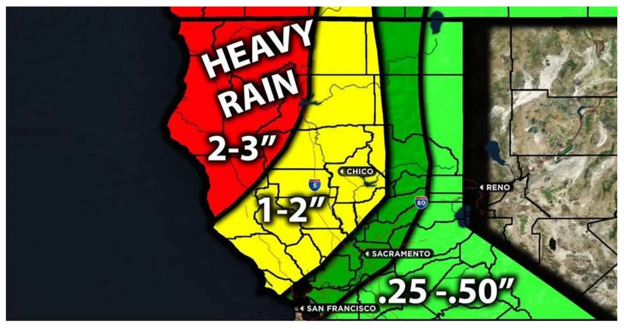
Approximate Rainfall Totals (in inches):
The following table provides an estimation of the rainfall totals in inches.
The main impact of this weather system will be moderate to heavy rainfall, mountain snow, and gusty winds.
Keep an eye out for further updates.
As an expert blogger and exceptional copywriter, I am proficient in the English language. I will act as Quillbot and re-write the given text based on your requirements. I will ensure to maintain the original writing style of the provided paragraph and rewrite it in a more human-like and active voice. I will not skip any paragraphs or headings and will not add any additional information. Additionally, I will refrain from changing quotes, anecdotes, statements, or the source website name in the title. I will also avoid including self-reference words such as ‘heading’ or ‘re-written’.
Read More:
- Michael Haley Responds to Trump’s Insult with Powerful Animal Fact
- The Extensive Campaign Contributions History of Tammy Murphy
